Bike parking at Birmingham New Street
30 bike parking spots with 347 spaces within a 5-minute walk of Birmingham New Street, 14 of them covered. 42 bikes were reported stolen on the streets within 500 m in the 12 months to September 2026, 28% fewer than the year before.
Bike stolen? What to do now, and make a stolen bike poster with the local groups for Birmingham.

Bike parking at New Street: quick answers
- Is there bike parking at the station itself? Yes: about 58 cycle spaces at the station, including secure parking. Details and sources below.
- Where can I lock my bike at New Street? The lowest-risk spot within a 5-minute walk: Sheffield stands on Navigation Street (2 min walk, 20 spaces). There are 30 public bike parking spots in that radius in all.
- Is there covered bike parking? Yes: 14 of the 30 spots within a 5-minute walk are covered; the lowest-risk covered spot: Sheffield stands on Navigation Street, 2 min walk.
- How common is bike theft around New Street? 42 bikes were reported stolen on the streets within 500 m in the 12 months to September 2026. Thefts inside the station are not in the police data (see below).
Birmingham New Street’s own cycle parking
- Spaces: about 58
- Sheltered: yes
- CCTV: yes
- Secure parking: a covered cycle pod on Hill Street by the Drop and Go entrance (since June 2021): 46 bikes plus 1 adapted-cycle space, 24-hour access with a Swift card after registering with TfWM, free, CCTV
- Where: Secure pod on Hill Street by the Drop and Go point
- Stands. National Rail lists 58 spaces; it is not clear whether that includes the pod.
Source: National Rail: Birmingham New Street station · Network Rail Media Centre: Birmingham New Street cycle pod opens (2021) · TfWM: Find bike storage at a station, checked October 2026.
These figures come from the railway, not from our map, so Rackfox gives them no theft-risk rating. If the same cycle park also appears in the lists below, its rating reflects thefts on the streets around it, not inside it. Thefts inside stations are missing from police open data (see below).
Lower-risk places to lock up near New Street
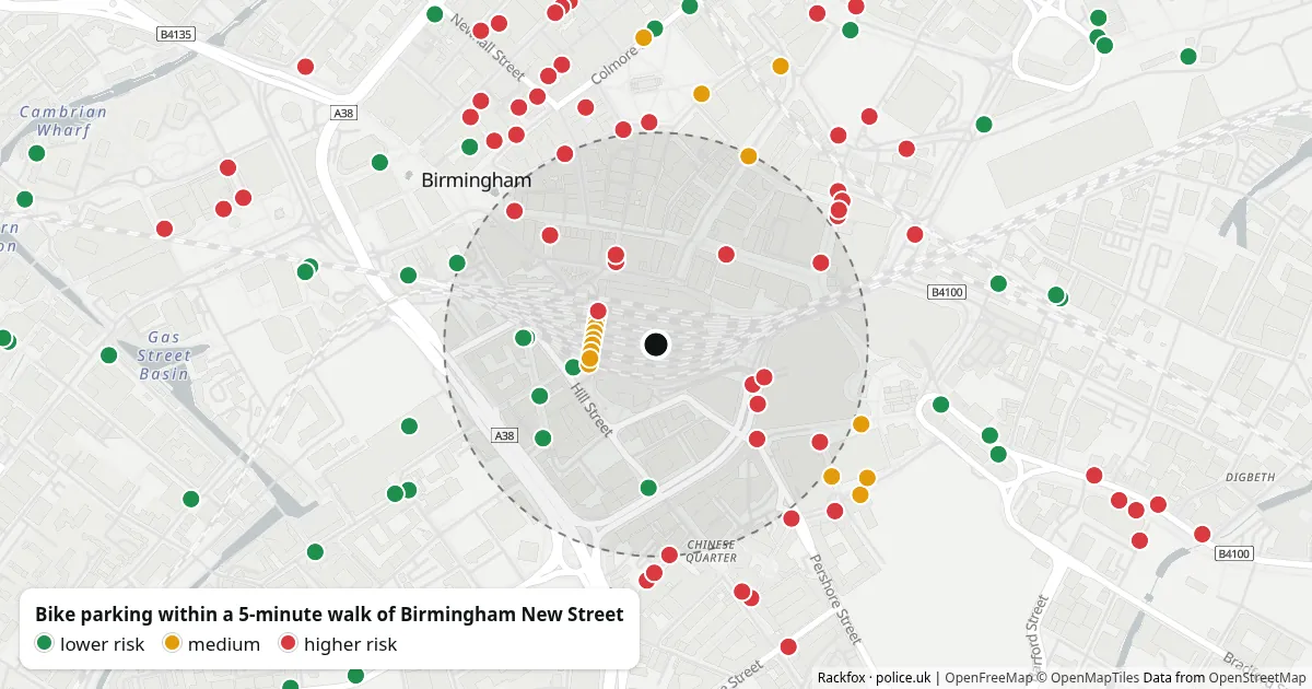
- Low Navigation Street Sheffield stands · 20 spaces · covered · 2 min walk Map ›
- Low Lower Severn Street Indoor bike park · 46 spaces · covered · lit · 3 min walk Map ›
- Low Lower Severn Street Bike rack · 6 spaces · 4 min walk Map ›
- Low Navigation Street Sheffield stands · 4 spaces · 4 min walk Map ›
- Low Bath Passage Bike parking · 2 spaces · 4 min walk Map ›
- Low Beak Street Sheffield stands · 12 spaces · 4 min walk Map ›
Lowest theft risk first, then the shortest walk: risk compares police-reported bike thefts within 150 m of each spot over the last 12 months with the rest of Birmingham’s bike parking. Private parking (residents, members) is left out. Street names are the nearest street in police data, so check the exact spot on the map. The same list as “Safer spots nearby” on the map.
Covered parking
Shelters, lockers and indoor bike parks within a 10-minute walk, lowest theft risk first:
Bike thefts around New Street
| Month | Thefts |
|---|---|
| October 2024 | 2 |
| November 2024 | 7 |
| December 2024 | 8 |
| January 2025 | 3 |
| February 2025 | 2 |
| March 2025 | 3 |
| April 2025 | 1 |
| May 2025 | 5 |
| June 2025 | 7 |
| July 2025 | 3 |
| August 2025 | 5 |
| September 2025 | 12 |
| October 2025 | 5 |
| November 2025 | 1 |
| December 2025 | 2 |
| January 2026 | 0 |
| February 2026 | 3 |
| March 2026 | 1 |
| April 2026 | 1 |
| May 2026 | 4 |
| June 2026 | 7 |
| July 2026 | 2 |
| August 2026 | 6 |
| September 2026 | 10 |
Bike thefts reported to the police on the streets within 500 m of the station, per month, last 24 months.
Streets nearby with the most thefts, last 12 months:
Thefts inside the station are recorded by British Transport Police, which has not supplied crime data to police.uk since early 2025 (police.uk changelog), so they are not counted here. The year before still includes a few thefts British Transport Police recorded up to January 2025, so part of any fall is this gap. Police place each theft “on or near” an anonymised point, and many thefts are never reported. Data & licences
Bike parking at other UK stations: London and major stations in other cities.
Find safe parking near you
The map shows every rack around New Street with its theft risk, and the Ladywood guide covers the whole ward.
Open the map at New Street